
ESurveying Softech: Urban Design and ESurvey CADD
Any infrastructure project starts with planning. The survey is conducted to help the urban designers plan infrastructure projects like Road Design, Canal, Layout Design, Water Supply, and Sewer Design.
Popular CAD Packages like AutoCAD, Micro Station, and BricsCAD are widely used in urban design projects. Since these tools are not specifically built on a specific stream of engineering, the plan and design using Standard Package alone will be difficult and time consuming. Understanding this need, many companies have developed various software packages to address the infrastructure industry's needs. ESurvey CADD is one such tool through which users can optimize their designs for space saving and less earthwork.
Using ESurvey CADD, many engineers have saved costs in multiple projects.
The following narrations illustrate how the software package helps engineers to save cost.
Better Earthwork Estimation: In levelling projects, if earthwork is planned in a way which does not involve bringing soil from another site or it does not demand dumping excess soil outside the work area, it will save cost. Using Earthwork module of ESurvey CADD, Optimum formation level for a given boundary can be found out. At many work sites, formation levels will be different in the same site for various reasons. In such cases also, cutting and filling can be found out for each boundary and engineers can ensure that total cutting and filling is same for entire work area, thereby avoiding the additional cost of transporting soil in and out from the work site.
Across the country, thousands of kilometres of road are getting improved under Pradhan Mantry Gram Sadak Yojana (PMGSY). Since these roads are not on either state or national highways, curve design is not given primary importance as road speed does not demand matching with national highways. Primary importance is given to ensure that roads are at least 7.5 meter wide. Using Section module of ESurvey CADD, engineers are able to estimate the lowest possible cost for improving the road to meet PMGSY standard requirements.
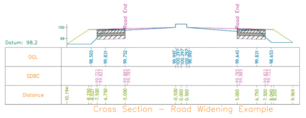
In states such as Kerala where buildings are constructed on either side of the road, the only option that is left for the public works department is to utilize all the space including footpath to be converted as a road. In the Section module of E-Survey CADD, there is specific feature called Road Widening, which prepares different layer drawings for only the additional width of the road.
As demand for more building is increasing, many sites are being converted into layouts. There is no specific software for designing the layout just by considering the layout surface. While developing layouts there will be many constraints, and parameters such as road accessibility to each plot, and bifurcation of land into roads need to be factored in, while the civic amenities have to be in compliance with the local municipality or corporations' rules. Normally such layout drawings are prepared using basic 2D drafting tools. E-Survey has developed set of lisp routines which are of great help to urban planning engineers, and save them considerable time in working with such drawings by developing code snippets within the CAD System.
Cost of land has been considerably increasing over a period of time. Acquisition of land for Public works is not as easy as earlier, and all these conditions demand fantastic engineering to ensure public comfort in infrastructure projects. Today's technology tools like AutoCAD and Specific CAD Packages, which address the engineers' need for optimum utilization of land like E-Survey CADD, are helping engineers to adapt to the situation. Considering the contribution of ESurvey CADD in Infrastructure projects, ESurvey CADD was awarded "Best Civil Engineering Software for the Year 2012" by Association of Consulting Civil Engineers (India).
Popular CAD Packages like AutoCAD, Micro Station, and BricsCAD are widely used in urban design projects. Since these tools are not specifically built on a specific stream of engineering, the plan and design using Standard Package alone will be difficult and time consuming. Understanding this need, many companies have developed various software packages to address the infrastructure industry's needs. ESurvey CADD is one such tool through which users can optimize their designs for space saving and less earthwork.
Using ESurvey CADD, many engineers have saved costs in multiple projects.
The following narrations illustrate how the software package helps engineers to save cost.
Better Earthwork Estimation: In levelling projects, if earthwork is planned in a way which does not involve bringing soil from another site or it does not demand dumping excess soil outside the work area, it will save cost. Using Earthwork module of ESurvey CADD, Optimum formation level for a given boundary can be found out. At many work sites, formation levels will be different in the same site for various reasons. In such cases also, cutting and filling can be found out for each boundary and engineers can ensure that total cutting and filling is same for entire work area, thereby avoiding the additional cost of transporting soil in and out from the work site.
Across the country, thousands of kilometres of road are getting improved under Pradhan Mantry Gram Sadak Yojana (PMGSY). Since these roads are not on either state or national highways, curve design is not given primary importance as road speed does not demand matching with national highways. Primary importance is given to ensure that roads are at least 7.5 meter wide. Using Section module of ESurvey CADD, engineers are able to estimate the lowest possible cost for improving the road to meet PMGSY standard requirements.
In states such as Kerala where buildings are constructed on either side of the road, the only option that is left for the public works department is to utilize all the space including footpath to be converted as a road. In the Section module of E-Survey CADD, there is specific feature called Road Widening, which prepares different layer drawings for only the additional width of the road.
As demand for more building is increasing, many sites are being converted into layouts. There is no specific software for designing the layout just by considering the layout surface. While developing layouts there will be many constraints, and parameters such as road accessibility to each plot, and bifurcation of land into roads need to be factored in, while the civic amenities have to be in compliance with the local municipality or corporations' rules. Normally such layout drawings are prepared using basic 2D drafting tools. E-Survey has developed set of lisp routines which are of great help to urban planning engineers, and save them considerable time in working with such drawings by developing code snippets within the CAD System.
Cost of land has been considerably increasing over a period of time. Acquisition of land for Public works is not as easy as earlier, and all these conditions demand fantastic engineering to ensure public comfort in infrastructure projects. Today's technology tools like AutoCAD and Specific CAD Packages, which address the engineers' need for optimum utilization of land like E-Survey CADD, are helping engineers to adapt to the situation. Considering the contribution of ESurvey CADD in Infrastructure projects, ESurvey CADD was awarded "Best Civil Engineering Software for the Year 2012" by Association of Consulting Civil Engineers (India).