Assessment of Earthquake Induced Liquefaction Hazard in Jammu & Kashmir: Step for Site Safety and Resilient Foundation
This study provides a database for designers working on the construction, development, and expansion-related projects in J&K for developing any prospective earthquake-induced liquefaction mitigation strategies.
Dr. Abdullah Ansari, Dept of Smart City Engineering, Inha University, Republic of Korea, and Dept of Civil Engineering, IIT Delhi
In this study, an attempt is made to generate hazard maps for the Jammu Region (JR) in Jammu and Kashmir in terms of surface peak ground acceleration (PGAsurface), liquefaction zonation, and vulnerability index (Kg). For the study, the seismic response in 200 sites was examined, and amplification factors at 0.01 s, 0.2 s, 1 s, and 10 s were estimated, based on site-specific PGAsurface. The calculated factor of safety from field approaches was normalised to produce an integrated liquefaction zonation map. Field data from geophysical testing was also used to generate a vulnerability distribution for the study area.
According to the findings, the southern portion of the JR has young sediments and alluvium deposits, resulting in low shear wave velocity (Vs) and very strong amplification. As a result, these sites are kept in high to very high vulnerable zones with Kg values of more than 35. This study provides a database for designers working on the construction, development, and expansion-related projects in J&K for developing any prospective earthquake-induced liquefaction mitigation strategies.
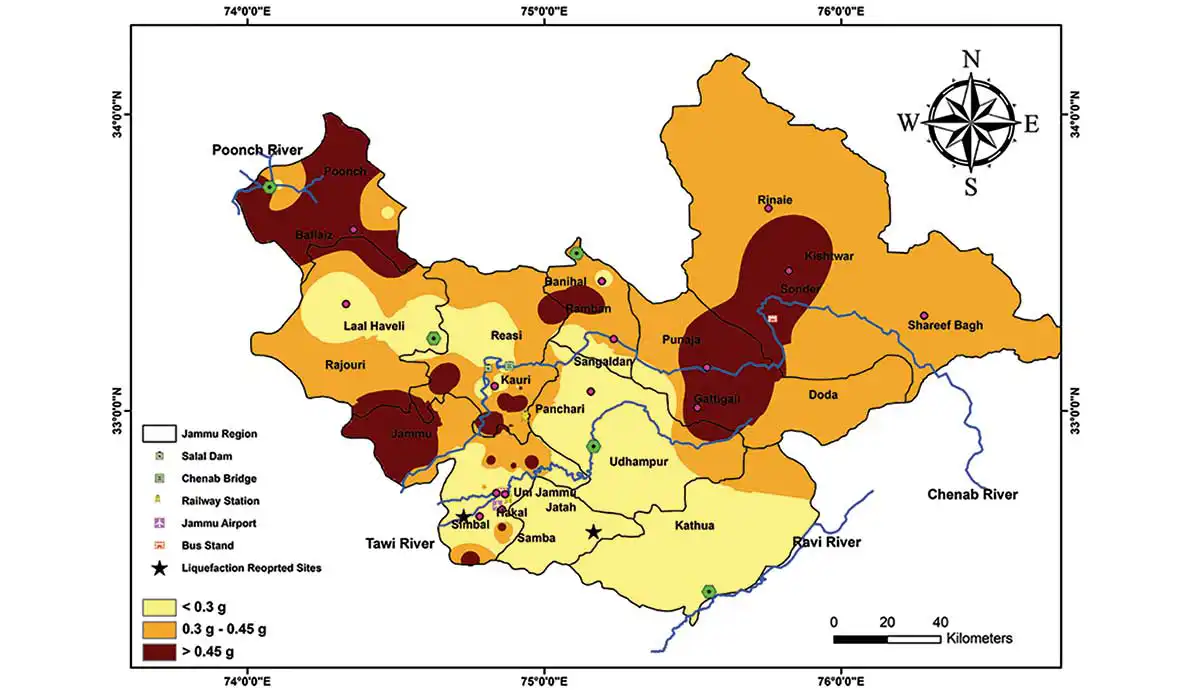 Figure 1: Surface peak ground acceleration (PGAsurface) map for Jammu Region (Jammu and Kashmir)
Geotechnical and geophysical data were collected from local consultants and field investigations, respectively. An extensive geophysical field study is conducted at 200 locations from where SPT (N) data is provided for boreholes. For data acquisition, Tromino® ENGY 3G is used for geophysical exploration and site characterisation. The shear wave velocity (Vs) based on MSOR is measured for shallow depth. The resonance frequency (f0) is recorded based on the concept of ambient noise measurements. The central part of the JR showed Vs30 values ranging from 350 to 425 m/s, whereas locations on the southern side have lower average shear wave velocities of 182 to 312 m/s. Beyond the Ravi River, particularly in the central region of Kathua, where it ranges between 380 and 570 m/s, an increase in Vs30 values are seen. Actual ground motions of five earthquakes in the region i.e. Uttarkashi (1991), Chamba (1995), Chamoli (1999), South Hindukush (2010) and Kishtwar (2013) were considered for ground response analysis.
The H/V amplitude (A) and resonance frequency (f0) estimated from the MHVSR can be used to evaluate the vulnerability index, as described in Eq. (1).
Kg= A2⁄f0 (1)
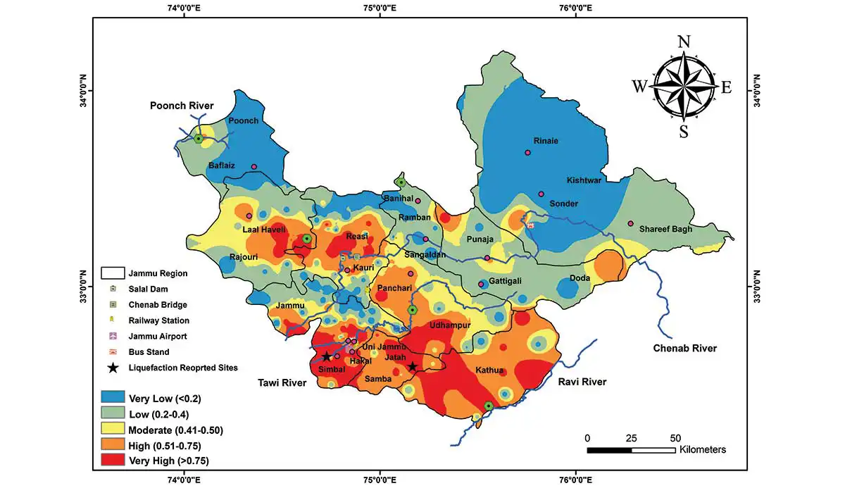 Figure 2: Liquefaction zones for Jammu Region (Jammu and Kashmir)
Based on the calculated values of Kg, the JR is divided into five zones of vulnerability. These zones show the severity as very low, low, moderate, high, and very high. The vulnerability map in Fig. 3 is in accordance with the local lithological and geological formations. The highest point on JR is at Sinthan Top, at the maximum altitude of 3784 m. Mountainous topography may be seen in most places in Reasi, Poonch, Ramban, Doda, and Kishtwar. Testing locations in these districts fall under one of two vulnerability categories: low or very low. The IGP, which makes up the southern portion of JR, has exceptionally soft alluvium. Soft soils and thick sedimentary layers in southern locations make them susceptible to potential damage from intense motion caused by either near-field or far-field earthquakes. Sites near the Tawi, Ravi, and Chenab Rivers have extremely high vulnerability.
In the event of moderate to large magnitude earthquakes, low resonance frequency (f0) and high H/V amplitude (A) are the most lethal and catastrophic damage-producing combinations. Outstanding f0 and A values in the regions of Khorbani, Jatah, and Simbal will cause liquefaction-related damages in these areas. Significant building and structural damages were observed due to the Kashmir and Mirpur far-field earthquakes in 2005 and 2019, respectively, in these regions. Site locations of Laal Haveli and Punjaja with f0 < 1 Hz present the vulnerability index ranging between 15 to 35. The majority of the sites in Poonch, Kishtwar, and the eastern part of Doda have extremely low Kg values (< 5). For Kg > 15, the central portion of the JR displays H/V amplitudes between 4.5 and 6.8. Sites in the southwestern part of Jammu, Kathua, Samba, and central Rajouri where Vs30 ranges between 182 to 560 m/s. These sites exhibit very high amplification and are vulnerable to severe structural damages in case of any seismic activities.
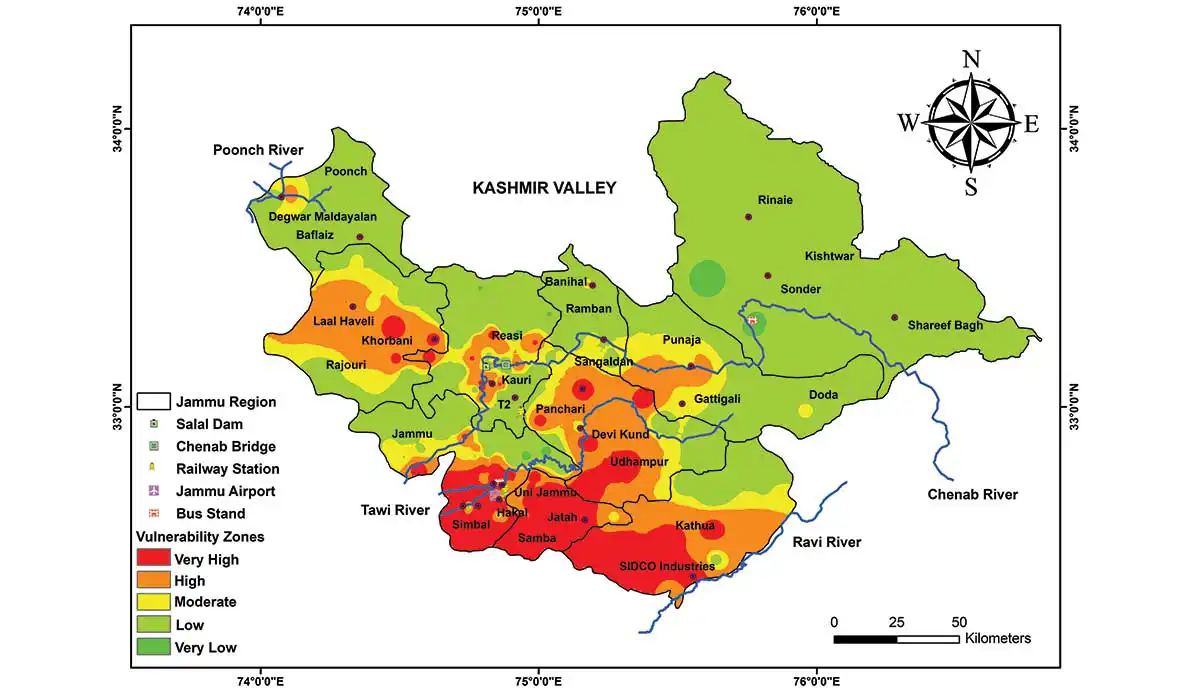 Figure 3: Vulnerability zones for Jammu Region (Jammu and Kashmir)
The majority of sites in southern Jammu, Samba, and Kathua have Vs of less than 230 m/s. The results of local geology and field investigations were used to adjust the ranges for liquefaction zones. The projected liquefaction zones are labelled as very low, low, moderate, high, and very high, with PL of 0.2, 0.2-0.4, 0.41-0.5, 0.51-0.75, and >0.75, respectively. The testing sites in the southern section have PL values more than 0.5. These locations are vulnerable to damage from either near-field or far-field earthquakes due to their fragile subsurface strata. The vulnerability indexing-based site grouping in JR was defined by means of resonance frequency (f0) and H/V amplitude. The findings concluded that more than half part of the JR is classified as moderate to high-risk zones. These findings can be used to analyse the seismic response of foundation soil and superstructures.
Dr. Abdullah Ansari, Dept of Smart City Engineering, Inha University, Republic of Korea, and Dept of Civil Engineering, IIT Delhi
In this study, an attempt is made to generate hazard maps for the Jammu Region (JR) in Jammu and Kashmir in terms of surface peak ground acceleration (PGAsurface), liquefaction zonation, and vulnerability index (Kg). For the study, the seismic response in 200 sites was examined, and amplification factors at 0.01 s, 0.2 s, 1 s, and 10 s were estimated, based on site-specific PGAsurface. The calculated factor of safety from field approaches was normalised to produce an integrated liquefaction zonation map. Field data from geophysical testing was also used to generate a vulnerability distribution for the study area.
According to the findings, the southern portion of the JR has young sediments and alluvium deposits, resulting in low shear wave velocity (Vs) and very strong amplification. As a result, these sites are kept in high to very high vulnerable zones with Kg values of more than 35. This study provides a database for designers working on the construction, development, and expansion-related projects in J&K for developing any prospective earthquake-induced liquefaction mitigation strategies.
Geotechnical & Geophysical Investigations
Jammu and Kashmir (J&K) is located in the northwestern part of the Himalayas triggered during 1555, 1828, 1885, 1905, 2005, 2013, and 2019 earthquake events. Southern portion of Jammu Region (JR) is a part of the Indo-Gangetic Plains (IGP), where the availability of soft soil and thick sedimentary strata is at its highest. Significant damages during past earthquakes at distant sites demonstrate the impact of the dynamic soil characteristics that lead to local site effectiveness. JR has been impacted due to the near-field as well as far-field earthquakes in the Himalayan region extending up to Hindukush in Afghanistan. The Jhelum Fault, Attock Fault, Reasi Thrust, Balakot-Bagh Fault, Deosai Fault, Jwalamukhi Thrust, Hanna Fault, Batal Fault, and Mawer Fault are few of the active seismic source that surrounds this area. Recently occurred far-field June 2022 Paktika earthquake (Mw=5.9) in Afghanistan and the 2019 Mirpur earthquake (Mw=5.6) in Pakistan are also showing the active dynamics of the tectonic plates in this region. Figure 1: Surface peak ground acceleration (PGAsurface) map for Jammu Region (Jammu and Kashmir)
Geotechnical and geophysical data were collected from local consultants and field investigations, respectively. An extensive geophysical field study is conducted at 200 locations from where SPT (N) data is provided for boreholes. For data acquisition, Tromino® ENGY 3G is used for geophysical exploration and site characterisation. The shear wave velocity (Vs) based on MSOR is measured for shallow depth. The resonance frequency (f0) is recorded based on the concept of ambient noise measurements. The central part of the JR showed Vs30 values ranging from 350 to 425 m/s, whereas locations on the southern side have lower average shear wave velocities of 182 to 312 m/s. Beyond the Ravi River, particularly in the central region of Kathua, where it ranges between 380 and 570 m/s, an increase in Vs30 values are seen. Actual ground motions of five earthquakes in the region i.e. Uttarkashi (1991), Chamba (1995), Chamoli (1999), South Hindukush (2010) and Kishtwar (2013) were considered for ground response analysis.
Ground Response Analysis
The deaggregation results were used as a basis to establish the magnitude and distance range. Based on these criteria, 10 records were chosen from a pool of 149. Typically, the effect of magnitude on spectral response is greater than the effect of epicentral distance. As a result, shorter magnitude range and broader epicentral distance range records were chosen. PGAsurface value of 0.05 g is considered to be sufficient to cause damage to poorly designed buildings. However, PGAsurface is not the only criteria for damage; there are various additional parameters that are essential from a damage standpoint, such as strong motion duration, building natural period and ground motion amplitude. The main causes of the low PGAsurface are the short duration of input bedrock motion, the longer source-to-site distance, and impedance contrast. Travelling a long distance with weak ground motion is likely to inflict less damage. Local site effects, on the other hand, play a significant part in devastation in the case of far-field earthquakes. PGAsurface in Shareef Bagh, Banihal, and Baflaiz is greater than 0.45 g. Maximum sites in Jammu, Samba, Kathua, and the central part of Udhampur have very low PGAsurface due to younger sediments and alluvium deposits near the Tawi and Ravi rivers, as illustrated in Fig. 1.Liquefaction Vulnerability
The standard penetration test (SPT), cone penetration test (CPT), and seismic tests to assess the shear wave velocity of soil deposits are the most often utilised field testing-based procedures for obtaining soil samples for liquefaction hazard study. The factor of safety is derived using the SPT (N) value and Vs-based approaches were given equal weightage for normalisation in order to estimate the probability of liquefaction (PL). A liquefaction zonation map for JR is presented in Fig. 2. Majority of the sites in the southern part are classified under High or Very High liquefaction zones. At all of these locations, Vs less than 230 m/s observed. High amplification is seen due to the presence of young sediments. The northern and northern western ends of JR include rock outcrops. Shear wave velocity of more than 600 m/s was measured at all such sites where very low amplification levels were detected.The H/V amplitude (A) and resonance frequency (f0) estimated from the MHVSR can be used to evaluate the vulnerability index, as described in Eq. (1).
Kg= A2⁄f0 (1)
 Figure 2: Liquefaction zones for Jammu Region (Jammu and Kashmir)
Based on the calculated values of Kg, the JR is divided into five zones of vulnerability. These zones show the severity as very low, low, moderate, high, and very high. The vulnerability map in Fig. 3 is in accordance with the local lithological and geological formations. The highest point on JR is at Sinthan Top, at the maximum altitude of 3784 m. Mountainous topography may be seen in most places in Reasi, Poonch, Ramban, Doda, and Kishtwar. Testing locations in these districts fall under one of two vulnerability categories: low or very low. The IGP, which makes up the southern portion of JR, has exceptionally soft alluvium. Soft soils and thick sedimentary layers in southern locations make them susceptible to potential damage from intense motion caused by either near-field or far-field earthquakes. Sites near the Tawi, Ravi, and Chenab Rivers have extremely high vulnerability.
In the event of moderate to large magnitude earthquakes, low resonance frequency (f0) and high H/V amplitude (A) are the most lethal and catastrophic damage-producing combinations. Outstanding f0 and A values in the regions of Khorbani, Jatah, and Simbal will cause liquefaction-related damages in these areas. Significant building and structural damages were observed due to the Kashmir and Mirpur far-field earthquakes in 2005 and 2019, respectively, in these regions. Site locations of Laal Haveli and Punjaja with f0 < 1 Hz present the vulnerability index ranging between 15 to 35. The majority of the sites in Poonch, Kishtwar, and the eastern part of Doda have extremely low Kg values (< 5). For Kg > 15, the central portion of the JR displays H/V amplitudes between 4.5 and 6.8. Sites in the southwestern part of Jammu, Kathua, Samba, and central Rajouri where Vs30 ranges between 182 to 560 m/s. These sites exhibit very high amplification and are vulnerable to severe structural damages in case of any seismic activities.
 Figure 3: Vulnerability zones for Jammu Region (Jammu and Kashmir)
Discussion
The Jammu Region (JR) of Jammu and Kashmir is located in the NW Himalayas which is one of the most active tectonic regions. This area has witnessed damage during far-field earthquakes that occurred in 2005 and 2019. In this study, ten different bedrock motions from the Himalayan region were considered and a one-dimensional seismic response analysis for the equivalent linear case has been done. For short periods, amplification is higher at sites with rock outcrops in the north and northwest, and lower at alluvium sites in the south. For long periods, the amplification is greater at Simbal and Jatah-like alluvium sites near the banks of the Tawi, Ravi, and Chenab rivers. In Shareef Bagh, Banihal, and Baflaiz, the PGAsurface is more than 0.45 g. The factor of safety (Fs) against liquefaction is calculated using both SPT (N) value and shear wave velocity (Vs) based field methods and results are superimposed to generate an integrated map of liquefaction zonation in the JR.The majority of sites in southern Jammu, Samba, and Kathua have Vs of less than 230 m/s. The results of local geology and field investigations were used to adjust the ranges for liquefaction zones. The projected liquefaction zones are labelled as very low, low, moderate, high, and very high, with PL of 0.2, 0.2-0.4, 0.41-0.5, 0.51-0.75, and >0.75, respectively. The testing sites in the southern section have PL values more than 0.5. These locations are vulnerable to damage from either near-field or far-field earthquakes due to their fragile subsurface strata. The vulnerability indexing-based site grouping in JR was defined by means of resonance frequency (f0) and H/V amplitude. The findings concluded that more than half part of the JR is classified as moderate to high-risk zones. These findings can be used to analyse the seismic response of foundation soil and superstructures.
NBM&CW SEPTEMBER 2023


